Arunachal Pradesh, nestled in the northeastern corner of India, is a state renowned for its breathtaking landscapes, rich cultural heritage, and diverse wildlife. Often overlooked due to its remote location and limited accessibility, Arunachal Pradesh offers a treasure trove of fascinating facts about its history, geography, climate, and society.
History of Arunachal Pradesh
Arunachal Pradesh’s history is a rich tapestry of ancient kingdoms and cultures. The region was once ruled by the Monpa kingdom of Monyul, flourishing between 500 BCE and 600 CE, which controlled the northwest parts of the state. In addition, local chiefdoms in the northwest were governed by the Monpa and Sherdukpen tribes. The Chutia kings of Assam also ruled over the foothills and plains of Arunachal Pradesh.
Historical excavations have unearthed significant sites such as the 14th-century Malinithan temples in West Siang, which reflect the influence of the Chutia dynasty. Bhismaknagar, an 8th-century heritage monument, hints at an advanced civilization in the region. Additionally, the 400-year-old Tawang Monastery, located in the far northwestern part of the state, is notable for its Buddhist heritage and as the birthplace of Tsangyang Gyatso, the sixth Dalai Lama.
Geographical Significance of Arunachal Pradesh
Arunachal Pradesh covers an area of 83,743 square kilometers (32,333 square miles), situated between 26.28° N and 29.30° N latitude and 91.20° E and 97.30° E longitude. The state’s highest peak is Kangto, standing at 7,060 meters (23,160 feet). The first rays of sunlight in India reach the villages of Dong and Vijaynagar, located respectively at accessible points and near the Myanmar border.
The major rivers of Arunachal Pradesh include the Kameng, Subansiri, Siang (Brahmaputra), Dibang, Lohit, and Noa Dihing, which play a crucial role in the state’s ecology and economy.
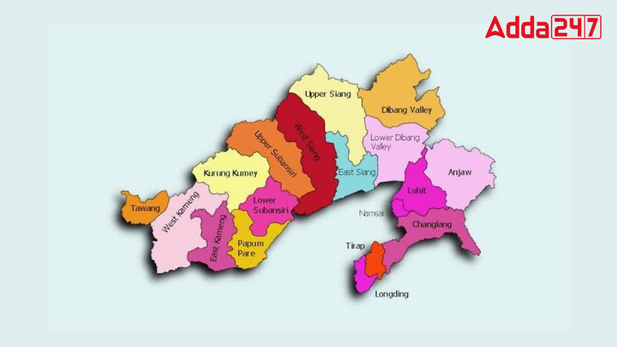
Area of Arunachal Pradesh
Arunachal Pradesh covers an area of 83,743 square kilometers (32,333 square miles). Located in northeastern India, this state is bordered by Bhutan to the west, the Tibet Autonomous Region of China to the north, Myanmar to the east, and Assam and Nagaland to the south. Its diverse topography ranges from lush valleys to high mountain peaks, making it one of the most geographically varied regions in India.
Climate of Arunachal Pradesh
Arunachal Pradesh’s climate varies significantly with altitude. Low-altitude areas experience a humid subtropical climate, while high-altitude regions (3500–5500 meters) have a mix of subtropical highland and alpine climates. The state receives annual rainfall ranging from 2,000 to 5,000 millimeters (79 to 197 inches), with the majority falling between May and October.
The Capital City of Arunachal Pradesh
Itanagar, the capital city of Arunachal Pradesh, is located in the southwestern part of the state, north of the Brahmaputra River. The city is a hub for industrial development and houses Arunachal University. As of the 2011 census, Itanagar had a population of 59,490.
Government and Society
Arunachal Pradesh is governed by the Indian Constitution of 1950, like most Indian states. The state’s administration includes a governor, an elected chief minister, a Council of Ministers, and a unicameral Legislative Assembly (Vidhan Sabha) nominated by India’s president. The state’s administrative structure comprises districts, subdivisions, blocks, towns, circles, and villages.
Arunachal Pradesh falls under the jurisdiction of the Assam High Court in Guwahati. A permanent bench of the Guwahati High Court has been established at Itanagar to handle cases from Arunachal Pradesh.
Education of Arunachal Pradesh
Despite having numerous elementary, middle, and secondary schools, Arunachal Pradesh’s literacy rate was among the lowest in India in the early 21st century. Arunachal University in Itanagar, established in 1984, and several specialty colleges in fields such as education, engineering, and agriculture, contribute to higher education in the state.


 Which River is known as the Rhine of Ind...
 Where is the World's Highest ATM Located...
 Top 10 Most Valuable Banks in the World ...