
Bihar, one of India’s most populous and historically rich states, is located in the eastern part of the country. To ensure smooth administration and balanced development, the state is divided into several districts. Each district has its own unique culture, geography, and economic importance. Together, these districts reflect the diversity and vibrant identity of Bihar’s people and traditions.
An Overview of Bihar
Bihar, one of the most historically rich and populous states in eastern India, is divided into several districts for smooth administration and development. Each district serves as a local administrative unit that helps the government implement policies, maintain law and order, and promote growth.
Number of Districts of Bihar
Currently, Bihar has 38 districts, which are grouped into 9 divisions. Every district is managed by a District Magistrate (DM), supported by officers who handle law enforcement, development programs, and revenue collection.
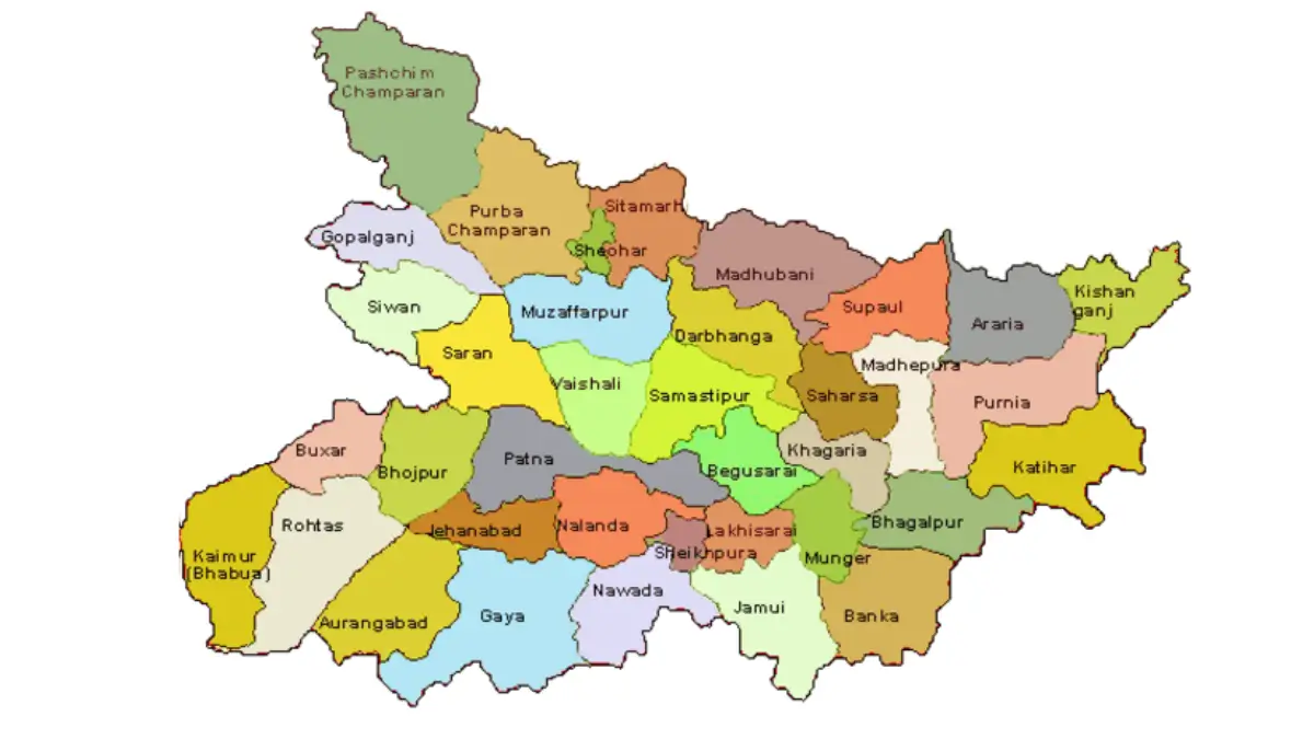
Bihar Districts List with Area and Population
Bihar, one of India’s most populous states, is divided into several districts for smooth governance and development. Each district has its own unique geography, culture, and population. Below is a detailed list of Bihar’s districts along with their area and population for better understanding and reference.
| Districts | Area | Population |
| Araria | 2,829 | 2,811,569 |
| Arwal | 637 | 699,000 |
| Aurangabad | 3,303 | 2,540,073 |
| Banka | 3,018 | 2,034,763 |
| Begusarai | 1,917 | 2,970,541 |
| Bhagalpur | 2,569 | 3,037,766 |
| Bhojpur | 2,473 | 2,728,407 |
| Buxar | 1,624 | 1,706,352 |
| Darbhanga | 2,278 | 3,937,385 |
| East Champaran | 3,969 | 5,099,371 |
| Gaya | 4,978 | 4,391,418 |
| Gopalganj | 2,033 | 2,562,012 |
| Jamui | 3,099 | 1,760,405 |
| Jehanabad | 1,569 | 1,125,313 |
| Khagaria | 1,486 | 1,666,886 |
| Kishanganj | 1,884 | 1,690,400 |
| Kaimur | 3,363 | 1,626,384 |
| Katihar | 3,056 | 3,071,029 |
| Lakhisarai | 1,229 | 1,000,912 |
| Madhubani | 3,501 | 4,487,379 |
| Munger | 1,419 | 1,367,765 |
| Madhepura | 1,787 | 2,001,762 |
| Muzaffarpur | 3,173 | 4,801,062 |
| Nalanda | 2,354 | 2,877,653 |
| Nawada | 2,492 | 2,219,146 |
| Patna | 3,202 | 5,838,465 |
| Purnia | 3,228 | 3,264,619 |
| Rohtas | 3,850 | 2,959,918 |
| Saharsa | 1,702 | 1,900,661 |
| Samastipur | 2,905 | 4,261,566 |
| Sheohar | 443 | 656,916 |
| Sheikhpura | 689 | 634,927 |
| Saran | 2,641 | 3,951,862 |
| Sitamarhi | 2,199 | 3,423,574 |
| Supaul | 2,410 | 2,229,076 |
| Siwan | 2,219 | 3,330,464 |
| Vaishali | 2,036 | 3,495,021 |
| West Champaran | 5,229 | 3,935,042 |
Bihar’s Largest District
West Champaran is the largest district in Bihar by land area, covering about 5,229 square kilometers. Located in the northwestern part of the state, it shares a border with Nepal. The district’s headquarters is Bettiah, and it is known for its rich agricultural land, cultural heritage, and the historic Champaran Satyagraha led by Mahatma Gandhi.
Bihar’s Smallest District
Sheohar is the smallest district in Bihar by area, covering only 443 square kilometers. Located in the northern part of the state, it was carved out of Sitamarhi district. Despite its small size, Sheohar is known for its fertile land and agriculture, mainly producing crops like paddy and maize. The district headquarters is also named Sheohar.

 Weekly Current Affairs One Liners (06th ...
 Who is known as the Father of Scientific...
 Which River is known as the River of Lif...


