Madhya Pradesh, situated in the heart of India, is famous for its rich cultural history and varied scenery. Among its numerous districts, Alirajpur is noteworthy as the westernmost district, contributing significantly to the state’s economy and progress.
An Overview of Madhya Pradesh
Madhya Pradesh covers 308,252 square kilometers, making it the second-largest state in India after Rajasthan and comprising 9.38% of the nation’s land area. Famous for its extensive landscapes, cultural diversity, and rich natural resources, this central state plays a vital role in India’s geographical diversity and heritage, greatly enriching its natural and cultural wealth.
Number of Districts in Madhya Pradesh
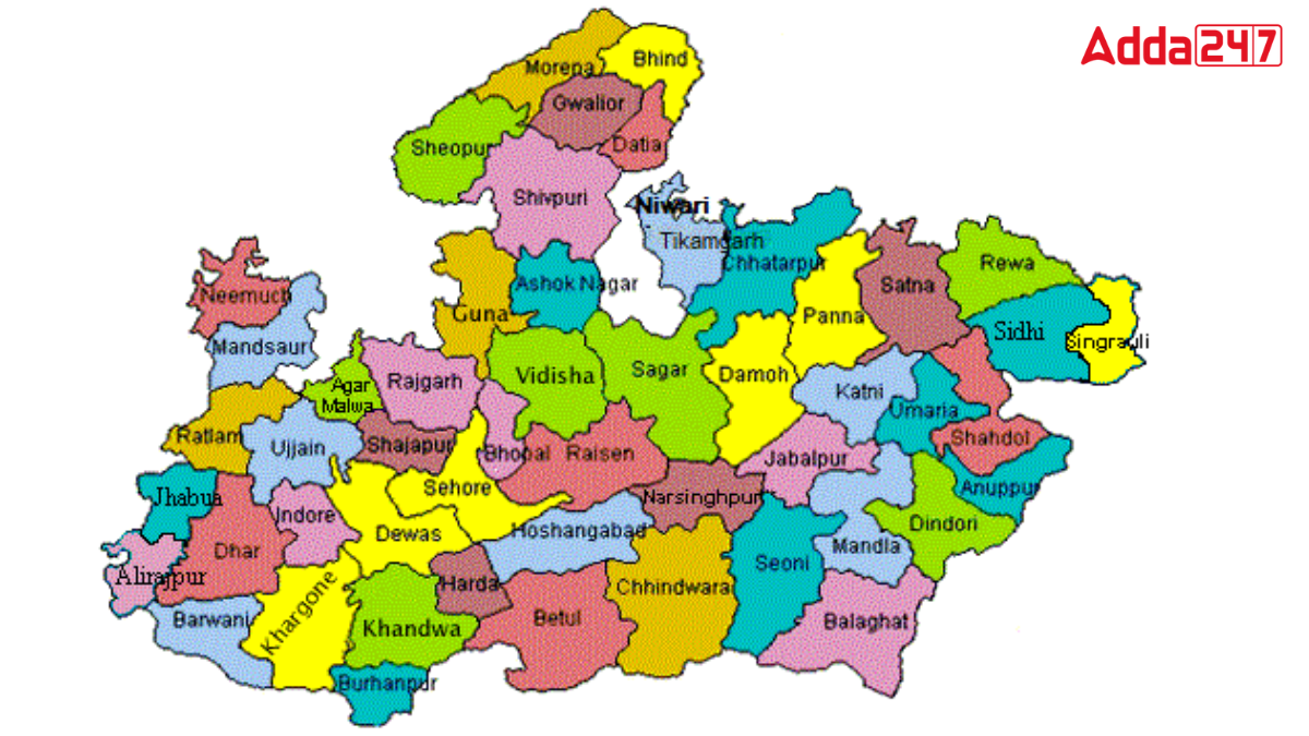
Madhya Pradesh, centrally positioned in India, is renowned for its rich cultural heritage. Spanning over 308,000 square kilometers, the state includes 55 districts, each with its unique significance and appeal. This diverse state forms a colorful tapestry of cultural wealth and administrative intricacies. This article delves into the distinct cultural and administrative aspects of Madhya Pradesh’s districts, highlighting their collective role in shaping the state’s identity and growth.
Geographical Extremes of Madhya Pradesh
- Northernmost District: Morena
- Southernmost District: Burhanpur
- Easternmost District: Singrauli
- Westernmost District: Alirajpur
Westernmost District of Madhya Pradesh
Alirajpur, situated in the westernmost part of Madhya Pradesh, borders Gujarat and Rajasthan. Known for its scenic landscapes and cultural heritage, it covers an area that spans 836 square kilometers. This district plays a pivotal role in the state’s economy, particularly in agriculture and tribal handicrafts. Alirajpur’s strategic location enhances cross-state trade and cultural exchanges, adding to its significance in regional development.
An Overview of Madhya Pradesh, the Westernmost District in Madhya Pradesh
Alirajpur, located in Madhya Pradesh’s Alirajpur district, was once part of a princely state under the Bhopawar Agency in Central India. Positioned in the Malwa region near Gujarat and Maharashtra, it covers an area of 836 square kilometers. With a population of 28,498 as of 2011, it reflects the state’s cultural diversity and historical significance, contributing to Madhya Pradesh’s rich heritage and regional dynamics.


 Which District is known as the Nellara o...
 Which River is known as the Moon River o...
 Which is the Highest Mountain of Austral...


