
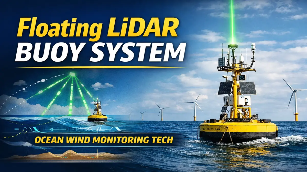
India has taken a major step in ocean technology with the successful testing of the Floating LiDAR Buoy System. This advanced system is designed to measure wind conditions over the sea with high precision. It will play an important role in improving weather forecasting, cyclone prediction, and offshore wind energy planning.
As India focuses more on renewable energy and climate monitoring, this innovation highlights the country’s progress in marine technology and scientific research. It also supports the vision of Atmanirbhar Bharat by promoting indigenous development.
What is Floating LiDAR Buoy System?
The Floating LiDAR Buoy System is a modern ocean-based device used to measure wind speed and direction over the sea.
- It uses LiDAR (Light Detection and Ranging) technology
- Installed on a floating buoy in the ocean
- Collects wind data at different heights above sea level
Unlike traditional wind measurement systems, this buoy can operate in deep sea areas where setting up physical towers is difficult. It provides accurate and continuous data, which is essential for ocean-based projects.
Key Features of Floating LiDAR Buoy
- Measures wind up to 300 metres above sea level
- Provides real-time and continuous data
- Works efficiently in remote ocean locations
- Uses laser-based high-precision technology
- More cost-effective and flexible than traditional systems
These features make it a reliable tool for long-term ocean monitoring and energy planning.
How Does Floating LiDAR Buoy Work?
The working of the Floating LiDAR Buoy System is based on laser technology and follows a simple process:
- The buoy floats on the ocean surface and remains stable
- It emits laser pulses into the atmosphere
- These pulses interact with tiny particles in the air
- The reflected signals return to the system
- Data is analysed to calculate wind speed and direction
This method helps scientists and researchers understand wind patterns over the ocean accurately and efficiently.
India’s Achievement
India has developed this system through the National Institute of Ocean Technology (NIOT), Chennai. The buoy was tested successfully near the Muttom coast in Tamil Nadu.
This development is significant because it reduces dependence on foreign technologies and strengthens India’s position in marine research and offshore energy development. It is also an important step toward achieving clean energy goals.
Why is This System Important?
The Floating LiDAR Buoy System is important for multiple reasons:
Better Weather Forecasting
It improves the accuracy of weather predictions, especially over oceans where data is limited.
Offshore Wind Energy Development
It helps identify suitable locations for setting up offshore wind farms, boosting renewable energy production.
Climate and Ocean Research
Continuous wind data helps in studying climate patterns and long-term environmental changes.
Disaster Management
Accurate wind data supports early warning systems for cyclones and storms, helping reduce damage.
Comparison: Traditional Methods vs LiDAR Buoy
| Feature | Traditional Wind Towers | LiDAR Buoy System |
|---|---|---|
| Location | Land-based | Ocean-based |
| Data Accuracy | Moderate | High |
| Height Coverage | Limited | Up to 300 m |
| Cost | Expensive | Cost-effective |
| Real-time Data | Limited | Yes |
Important Facts for Exams
- Technology Used: LiDAR (Light Detection and Ranging)
- Developed by: NIOT, Chennai
- Wind Measurement Range: Up to 300 metres
- Test Location: Tamil Nadu coast (Muttom)
- Application: Weather forecasting, wind energy, climate studies

 INS Aridhaman Nuclear Submarine Joins In...
 INS Sunayna Reaches Male, Boosting Marit...
 BRO's Project Chetak Turns 47: How It St...


