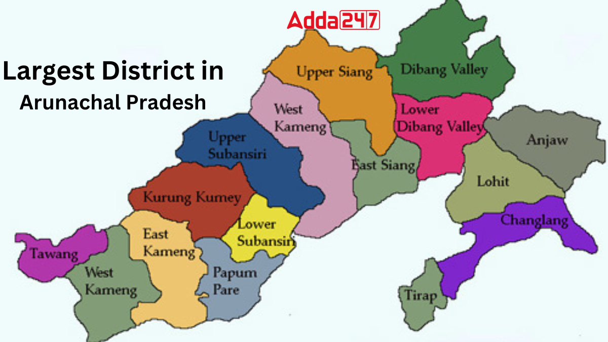
Arunachal Pradesh, located in the northeastern part of India, is the country’s largest state in this region by area. Known as the “Land of the Rising Sun”, it shares international borders with China, Bhutan, and Myanmar. The state is famous for its scenic beauty, tribal culture, and biodiversity. Administratively, Arunachal Pradesh is divided into several districts, and among them, one stands out as the largest district by area.
How many districts are there in Arunachal Pradesh?
Arunachal Pradesh comprises 26 districts. Initially designated as a Union Territory in 1972, it attained full statehood in India on 20 February 1987. Calls for the creation of new districts have been prevalent in the region. To maintain law and order within these districts, the government appoints Deputy Commissioners or District Magistrates, supported by Superintendents of Police, to oversee administrative matters.
Largest District in Arunachal Pradesh
Dibang Valley, the largest district of Arunachal Pradesh, reflects the natural beauty and cultural richness of the state. Known for its vast forests, snow-capped mountains, and diverse wildlife, the district offers a glimpse of untouched wilderness. It is also home to unique tribal traditions and warm hospitality. With its breathtaking landscapes and deep cultural roots, Dibang Valley stands as a symbol of Arunachal Pradesh’s heritage and endless opportunities for exploration.
Key Facts Related to the Biggest District of Arunachal Pradesh
Here are the key facts you must know about Dibang Valley district of Arunachal Pradesh which is its biggest district by land area:
- Established on June 1st, 1980, Dibang Valley District was carved out from Lohit District.
- Named after the Dibang River, it comprises three major rivers: Dri, Mathun, and Talon, along with smaller rivers like Ahi, Awa, and Emra.
- Bounded by Lohit, Lower Dibang Valley, East Siang, and Upper Siang districts, as well as China.
- Spans an area of 9129 sq. kms with a population of 8004 (2011 census).
- Bifurcated into Upper Dibang Valley and Lower Dibang Valley districts on December 16th, 2001.
- Features undulated-rugged mountains, green valleys, deep gorges, enchanting waterfalls, and natural lakes.
- Boasts a temperate climate, heavy rainfall, and diverse wildlife.
- Rich in flora and fauna, with medicinal plants like Coptis Teeta (Eroh) and Taxux Bacata.
- Celebrates festivals like Reh (1st February) and Ke-Meh-Ha (24th September)
- Located in the northeasternmost corner of Arunachal Pradesh, bound by international borders with Tibet and China.
- District headquarters situated in Anini, at an altitude of 1968 meters above sea level.
- Offers potential tourist spots like Mipi, Alinye (ALG), Angrim Valley, and more.
- Ideal for trekking, picnicking, angling, paragliding, and rock climbing.
- Paragliding introduced for the first time in Anini on January 17th, 2003, by the parachuting team of 29 Assam Rifles.
Largest District in Arunachal Pradesh By Population
Papumpare stands as the most populous district in Arunachal Pradesh, with a population of 176,573. Situated in the heart of the state, Papumpare district encompasses vibrant communities, bustling towns, and cultural diversity. Its significant population reflects the district’s central role in the socio-economic landscape of Arunachal Pradesh, contributing to its dynamic and evolving character.
Arunachal Pradesh All Districts Name List
Here is the list of 26 districts of Arunachal Pradesh:
| Districts of Arunachal Pradesh | |||
| S. No. | District | Area (in sq. km) | Formation |
| 1. | Anjaw | 6,190 | 2004 |
| 2. | Changlang | 4,662 | 1987 |
| 3. | Kamle | 200 | 2017 |
| 4. | Kra Daadi | 2,202 | 2015 |
| 5. | Kurung Kumey | 8,818 | 2001 |
| 6. | Lepa-Rada | 2018 | |
| 7. | Lohit | 2,402 | 1980 |
| 8. | Longding | 1,200 | 2012 |
| 9. | Namsai | 1,587 | 2014 |
| 10. | Pakke-Kessang | 2018 | |
| 11. | Papum Pare | 2,875 | 1992 |
| 12. | Shi-Yomi | 2,875 | 2018 |
| 13. | Siang | 2,919 | 2015 |
| 14. | Tawang | 2,085 | 1984 |
| 15. | Tirap | 2,362 | 1965 |
| 16. | Lower Dibang Valley | 3,900 | 2001 |
| 17. | Dibang Valley | 9,129 | 2001 |
| 18. | East Kameng | 4,134 | 1980 |
| 19. | West Kameng | 7,422 | 1980 |
| 20. | East Siang | 4,005 | 1980 |
| 21. | Lower Siang | 2017 | |
| 22. | Upper Siang | 6,188 | 1994 |
| 23. | West Siang | 8,325 | 1980 |
| 24. | Lower Subansiri | 3,460 | 1980 |
| 25. | Upper Subansiri | 7,032 | 1980 |
| 26. | Itanagar | 200 | 2022 |


 Which Place is known as the Diamond Capi...
 List of Major LPG Gas Companies in India...
 Which Fish Can Produce Electricity?