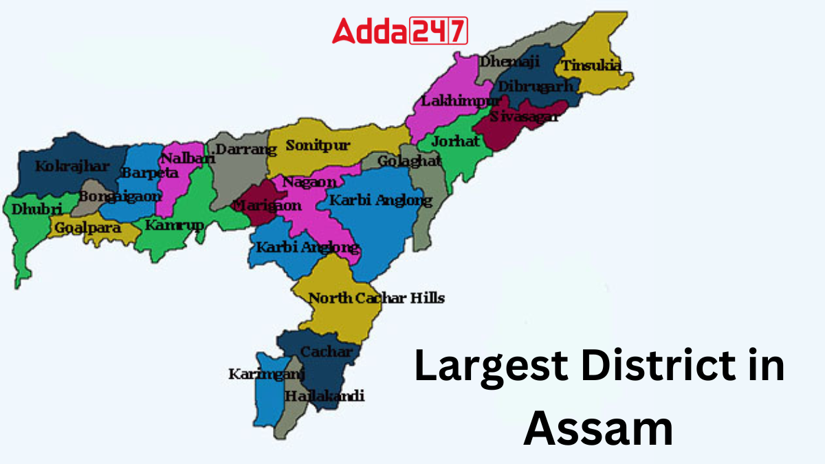
Assam, located in the northeast of India, is a state known for its tea gardens, wildlife, rivers, and cultural diversity. For smooth administration, the state is divided into several districts, each with its own significance in terms of history, resources, and geography. As of now, Assam has 35 districts, and among them, one holds the position of being the largest district by area. Knowing this list is important for general knowledge and exam preparation.
How many Districts are there in Assam?
Assam, a beautiful state in Northeast India, is divided into 35 administrative districts. These districts ensure better governance, development, and management across the state. Each district has its own cultural and geographical importance, making Assam diverse and unique in many ways.
Largest District in Assam
Karbi Anglong district, nestled in the picturesque landscapes of Assam, stands as the largest administrative district in the state. With its rich cultural heritage, diverse flora and fauna, and unique history, Karbi Anglong offers a tapestry of experiences for visitors and residents alike. This article explores the various aspects of Karbi Anglong, shedding light on its geographical, historical, cultural, and economic significance.
Key Facts Related to Assam’s Largest Districts
Here are some key facts related to Karbi Anglong, the largest district of Assam:
- Karbi Anglong District, the largest in Assam, was established in 1951 as United Mikir and North Cachar Hills District, later bifurcated into Mikir Hills and North Cachar Hills, and renamed Karbi Anglong in 1976.
- West Karbi Anglong district, formed in 2016, comprises the former Hamren Civil Sub-division and operates under the Karbi Anglong Autonomous Council.
- The district experiences diverse climates due to its varied topography, with winters lasting from October to February and summer temperatures ranging from 23°C to 32°C.
- Predominantly tribal, the population includes Karbis, Bodos, Kukis, Dimasas, Hmars, Garos, Rengma Nagas, Tiwas, and Man (Tai Speaking) communities.
- Karbi Anglong is rich in rivers like Dhansiri, Dikharu, Deopani, Nambor, and Jamuna, along with significant forest cover spanning 4,922.019 sq. km.
- The highest peak is Singhason at 1360 meters above sea level, with notable minerals including limestone, china-clay, feldspar, and coal.
- Agriculture is the primary occupation, with paddy being the main crop, cultivated mainly through the jhum system.
- The district is well-connected by road via NH-36 and NH-39, with distances of 259 km from Guwahati and 55 km from Dimapur to Diphu.
- The F. Railways passes through the district, touching points like Borlangphar, Langsoliet, Nilalung, Diphu, and others.
- The nearest airport is in Dimapur, located 2 km away from Diphu.
- Industries include the Bokajan Cement Plant, Karbi Chemical Mini Cement Plant (under construction), food processing units, rubber and citronella plantation industries, and 15 tea gardens in the district.
Largest District in Assam By Population
Nagaon stands as the largest district in Assam by population, boasting a significant populace of 2,823,768 individuals. Located in the central part of the state, Nagaon is renowned for its rich cultural heritage, diverse demographics, and historical significance. With its vibrant communities and bustling towns, Nagaon contributes significantly to the social and economic fabric of Assam.


 Which River is known as the Black River?...
 Which State is the Largest Producer of C...
 Which State is the Largest Producer of J...


