
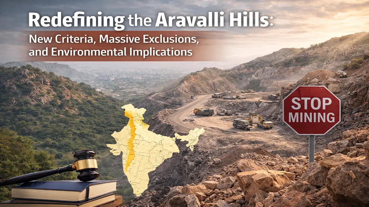
The Aravalli Hills, one of the oldest mountain ranges in the world, play a crucial role in India’s ecology, especially in preventing desertification, regulating groundwater, and protecting biodiversity in Rajasthan, Haryana, Delhi, and Gujarat.
Recently, a new official definition of the Aravalli Hills, approved by the Supreme Court in November 2025, has triggered intense debate. Environmental experts fear that the new definition could exclude large parts of the Aravallis from protection, making them vulnerable to mining, real estate projects, and infrastructure development.
Why Are the Aravallis in the News?
The controversy began after the Union Environment Ministry introduced a new method to define what qualifies as the Aravalli Hills.
While the government insists there is no immediate ecological threat, critics argue that the change could drastically shrink the legally recognised area of the Aravallis, weakening long-term environmental protection.
The New Aravalli Definition: What Has Changed?
100-Metre Local Relief Benchmark
Under the new definition:
- Only landforms that rise at least 100 metres above the surrounding local terrain are classified as part of the Aravalli Hills.
- Their slopes and nearby areas are also included.
- If two such hills are within 500 metres, the land between them is also treated as Aravalli, even if it is flat.
Why This Matters
Earlier, the Aravallis were identified using a broader scientific method, which included low-height but ecologically important hills. The new approach focuses on relative height, not overall elevation.
What Remains Protected Despite the New Definition?
The government has clarified that several sensitive areas remain protected, regardless of the new Aravalli definition:
- Tiger reserves (e.g., Sariska, Ranthambhore)
- National parks and wildlife sanctuaries
- Eco-Sensitive Zones (ESZs)
- Notified wetlands
- Compensatory afforestation plantations
These areas remain closed to mining and construction unless permitted under strict wildlife or forest laws.
Why Protection Is Not Always Permanent
Environmental protection in India can be changed or diluted through notifications.
A recent example:
- Attempts were made to redefine the Sariska Tiger Reserve boundaries, which could have allowed mining nearby.
- The move was stopped only after Supreme Court intervention.
This raises concerns that current protections may not guarantee long-term safety.
What the New Definition Excludes
FSI’s Earlier Method (Now Overlooked)
The Forest Survey of India (FSI) earlier identified Aravalli land using:
- A minimum elevation benchmark (115 m in Rajasthan), and
- A slope of at least 3 degrees.
Using this method:
-
Aravallis covered 40,483 sq km across 15 districts of Rajasthan.
Impact of the New Definition
Applying the 100-metre local relief rule would exclude:
- 99.12% of the Aravalli land earlier identified by FSI in these districts.
- Only 1,048 sq km out of 1,18,575 sq km would remain officially recognised.
This represents a massive reduction in the recognised Aravalli footprint.
Entire Districts Dropped from the Aravalli List
Several districts earlier recognised as Aravalli-bearing are now excluded, including:
- Sawai Madhopur – location of Ranthambhore Tiger Reserve
- Chittorgarh – home to a UNESCO World Heritage fort on an Aravalli outcrop
- Nagaur – where FSI mapped over 1,100 sq km as Aravalli
Rajasthan, which holds nearly two-thirds of the Aravalli range, is the most affected.
The Mining Argument: Why Critics Are Not Convinced
Government’s Claim
- Mining is allowed in only 0.19% of the Aravalli area.
- The government cites a total Aravalli extent of 1.44 lakh sq km.
Critics’ Counter-Argument
- The cited area includes the entire landmass of 34 districts, not the actual hill range.
- This overstates the size of the Aravallis and downplays mining pressure.
- Illegal mining and future mining expansion remain serious concerns.
Environmental Risks Beyond Mining
Mining is not the only threat.
By removing large hilly areas from the Aravalli definition:
- Real estate projects may expand, especially in Delhi NCR
- Infrastructure development could fragment remaining ecosystems
- Groundwater recharge zones may be lost
- Heat stress and air pollution risks may increase in urban regions
What the Government Told the Supreme Court
The Environment Ministry argued that:
- The 100-metre benchmark would include more area than the FSI’s 3-degree slope method.
- In 12 out of 34 districts, average slopes are below 3 degrees.
Why This Argument Is Questioned
- District averages mix plains and hills, hiding the true slope of hilly areas.
- Elevation measured from local profiles can exclude genuine hills if surrounding land is already high.
The Core Debate: Inclusion vs Exclusion
Committee’s View
- Not every hill is Aravalli.
- Over-inclusion could wrongly restrict non-Aravalli land.
Critics’ Concern
- The policy focuses more on avoiding inclusion errors than preventing harmful exclusions.
- Excluding genuine Aravalli landscapes could permanently weaken environmental protection.

 Who is known as the Father of Scientific...
 Which River is known as the River of Lif...
 Who is known as the King of the Deccan?


