
The entire country will be covered by Doppler Weather Radar Network by 2025 to help predict extreme weather events more accurately, union minister Jitendra Singh said, speaking at the foundation day of India Meteorological Department. Four new radars were added recently taking the number from 33 to 37. They include two at Murari Devi and Jot in Himachal Pradesh, and one each at Banihal Top in Jammu and Kashmir and Surkandaji in Uttarakhand covering a radius of 100 km.
Buy Prime Test Series for all Banking, SSC, Insurance & other exams
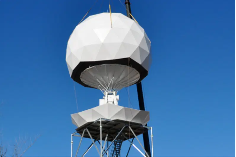
More About This Deployment:
The IMD has taken proactive steps to increase the number of radars from 15 in 2013 to 37 in 2023 and will add 25 more in next 2-3 years, he said in presence of Chief Ministers of Himachal Pradesh and Uttarakhand and LG of J&K—the three Himalayan States most prone to the extreme events in the country. While two more radars mean that 70 per cent of Himachal will be covered, there is need for more, including one at Lahaul-Spiti–which is also of strategic importance due to proximity to the China Border touching J&K and Ladakh.
About Doppler effect:
- Doppler Effect refers to the change in wave frequency during the relative motion between a wave source and its observer.
- It was discovered by Christian Johann Doppler who described it as the process of increase or decrease of starlight that depends on the relative movement of the star.
- Doppler Effect works on both light and sound objects
Radars (Radio Detection and Ranging):
- It is a device that uses electromagnetic waves in the microwaves region to detect location (range & direction), altitude, intensity and movement of moving and non-moving objects.
- It has its own source of illumination (a transmitter) for locating targets.
What is Doppler Weather Radar (DWR):
- It is a specialized radar that uses the Doppler effect to produce velocity data about objects at a distance.
- It is designed to improve precision in long-range weather forecasting and surveillance using a parabolic dish antenna and a foam sandwich spherical radome.
- It has the equipment to measure rainfall intensity, wind shear and velocity and locate a storm centre and the direction of a tornado or gust front.
- It provides advanced information, enhancing the lead-time so essential for saving lives and property, in the event of natural disaster associated with severe weather.
- Division of Doppler Radars and their applications: Doppler radar can be divided into several different categories according to the wavelength which are L, S, C, X, K.
Why Doppler radars:
Increasing incidents of flash floods and cloudbursts in the hill states of Himachal Pradesh, Uttarakhand and Jammu and Kashmir and other parts of the country due to climate change has led to increasing need for accurate forecasting for such events.
Accurate predictions are needed to save lives and forecast of weather, including monsoon and cyclones given the fact that India’s GDP is largely dependent on agriculture, short and long term planning and strategy development.


 MeitY Launches NIDAR 2.0 to Accelerate I...
 India's Wholesale Inflation Rises to 9.8...
 Jio Platforms Appoints Pankaj Pawar as C...

