
The longstanding Sir Creek dispute between India and Pakistan has re-entered the spotlight after Defence Minister Rajnath Singh issued a stern warning against any hostile action in the region, promising a “resounding and decisive response” that could alter “history and geography.” The dispute, though overshadowed by larger issues like Kashmir and Siachen, remains a strategic and economic flashpoint.
What is Sir Creek?
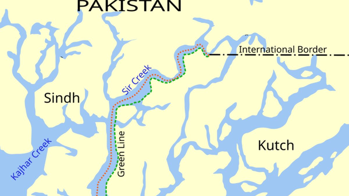
Sir Creek is a 96-km-long tidal estuary in the Rann of Kutch, located between Gujarat (India) and Sindh (Pakistan). It flows into the Arabian Sea and serves as the maritime boundary endpoint between the two nations.
Its importance stems from its impact on,
- Security and military access
- Fishing rights for coastal communities
- Oil and gas exploration potential
Determination of the Exclusive Economic Zone (EEZ) in the Arabian Sea
Nature of the Dispute
The core of the dispute lies in differing interpretations of the 1914 Bombay Government Resolution, signed between the British-controlled Sindh and the Ruler of Kutch.
Competing Claims
- Pakistan’s View: The boundary lies along the eastern bank, giving the creek to Pakistan.
- India’s Stand: The boundary must follow the thalweg principle — the mid-channel of navigable waters, which would give India more territory.
- Pakistan argues that Sir Creek is non-navigable, so the thalweg rule doesn’t apply.
India counters that it is navigable at high tide, justifying its EEZ claim under international maritime law.
Strategic and Diplomatic Relevance
1. Military Tensions
The estuary’s proximity to the international border makes it sensitive. Any incursion or provocation could escalate tensions quickly. The area is patrolled by the Indian Navy and Coast Guard, with Pakistani forces maintaining a presence on the other side.
2. EEZ and Resource Claims
Control over Sir Creek significantly influences maritime claims. The EEZ (200 nautical miles) is critical for undersea oil, gas, and fishing resources. The difference in interpretation could affect thousands of square kilometres of sea territory.
3. Diplomatic Status
Though flagged in composite dialogue rounds and Track-II diplomacy, the dispute has remained unresolved due to mutual distrust and competing strategic calculations.
Latest Development
In October 2025, Defence Minister Rajnath Singh declared that any Pakistani aggression near Sir Creek would invite a decisive Indian response. His remarks reflect,
- A hardening of India’s security posture
- A possible reaction to increased Pakistani maritime activity or troop movement
- An attempt to deter fishing-related intrusions and territorial encroachments
- This warning adds Sir Creek to the growing list of border sensitivities amid a volatile regional security environment.
Key Facts
- Sir Creek length: 96 km, located in Rann of Kutch
- India’s claim: Thalweg (mid-channel) principle
- Pakistan’s claim: Eastern bank boundary
- Legal origin: 1914 Bombay Government Resolution
- Recent update: Rajnath Singh’s October 2025 warning
- Strategic value: EEZ, resource access, military security

 Preeti Saran Re-Elected as UN Committee ...
 Global Trade Hits New High in 2025: Key ...
 Iran–US Ceasefire: Iran’s 10 Conditions ...


