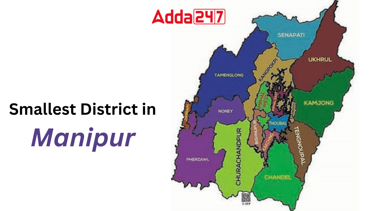
Nestled in the northeastern part of India lies the beautiful state of Manipur, known for its picturesque landscapes, rich cultural heritage, and diverse ethnic communities. Among its many districts, Bishnupur stands out as the smallest in terms of geographical area. Despite its size, Bishnupur holds immense significance in the cultural and historical tapestry of Manipur.
Smallest District in Manipur, Name
Bishnupur district, located in the northeastern state of Manipur, India, holds significance as the smallest district within the state. It boasts a rich cultural heritage, historical landmarks, and diverse demographics, making it a unique region within Manipur.
The district derives its name from a Vishnu temple situated at Lamangdong, signifying the historical and cultural roots embedded within the region.
Smallest District in Manipur – Area
Covering a total land area of 496 square kilometers (192 square miles), Bishnupur district stands as the epitome of compactness in Manipur’s administrative divisions. Despite its relatively small expanse, the district encapsulates a myriad of geographical features, cultural landscapes, and socio-economic dynamics.
Smallest District of Manipur – Geography
Bishnupur town serves as the administrative hub of the district, while other significant towns include Nambol, Moirang, Ningthoukhong, and Kumbi. The district encompasses various villages, including Nachou, Ngaikhong Khullen, Toubul, and Khoijuman Khullen, each contributing to the socio-cultural fabric of the area.
Flora and Fauna of Bishnupur, Manipur’s Smallest District
One of the notable features of Bishnupur district is the presence of the Keibul Lamjao National Park, established in 1977. Spanning an area of 40 square kilometers, this national park hosts diverse flora and fauna, adding to the ecological richness of the region.
Manipur’s Smallest District – Demographics
The demographic landscape of Bishnupur district reflects a steady growth in population over the years. According to the 2011 census, the district recorded a population of 237,399 inhabitants, with a population density of 485 individuals per square kilometer. The district exhibited a population growth rate of 15.36% from 2001 to 2011.
In terms of demographic composition, Scheduled Castes comprised 9.31% of the population, while Scheduled Tribes accounted for 1.38% in 2011. The district’s religious demographics indicate a predominant adherence to Hinduism, followed by Sanamahi, Islam, Christianity, and other faiths.
Langauge and Culture of Smallest District in Manipur
Meiteilon, the primary language spoken in Bishnupur district, is embraced by 97.87% of the population. Additionally, minority languages such as Rongmei, Nepali, Bengali, Hindi, and Thadou contribute to the linguistic diversity of the region. The cultural landscape is characterized by vibrant traditions, festivals, and indigenous practices that reflect the rich heritage of Manipur.
Smallest District of Manipur – Administration Divisions
Bishnupur district is administratively subdivided into three sub-divisions: Nambol, Bishnupur, and Moirang. Several towns, including Nambol, Oinam, Ningthoukhong, Moirang, Kwakta, and Kumbi, serve as significant centers of economic and social activity within the district.
Manipur State at a Glance
- Country: India
- Region: Northeast India
- Status: Formerly a union territory in 1956, attained statehood in 1972
- Capital and Largest City: Imphal
- Districts: 16
- Governor: Anusuiya Uikey
- Chief Minister: N. Biren Singh (BJP)
- State Legislature: Unicameral Manipur Legislative Assembly (60 seats)
- National Parliament Representation: 1 seat in Rajya Sabha, 2 seats in Lok Sabha
- High Court: Manipur High Court
- Area: Total of 22,327 square kilometers (8,621 square miles), ranking 23rd in India
- Population (2011): Total population of 2,855,794, ranking 23rd in India, with a population density of 130/km2
- Official Language: Manipuri, written in Meitei script
- Literacy Rate (2011): 76.94%, ranking 18th in India
- Sex Ratio (2011): 985 females per 1000 males


 Which Country is the Largest Ginger Prod...
 What is the Old Name of Indonesia? Check...
 What is the Emblem of India? Know Its Na...


