Nestled in the lap of the majestic Himalayas, the Indian state of Sikkim is renowned for its breathtaking landscapes, rich cultural heritage, and vibrant biodiversity. Amidst the towering peaks and lush greenery, lies the smallest district in Sikkim, a hidden gem waiting to be discovered by travelers seeking tranquility and natural beauty.
Smallest District in Sikkim, Name
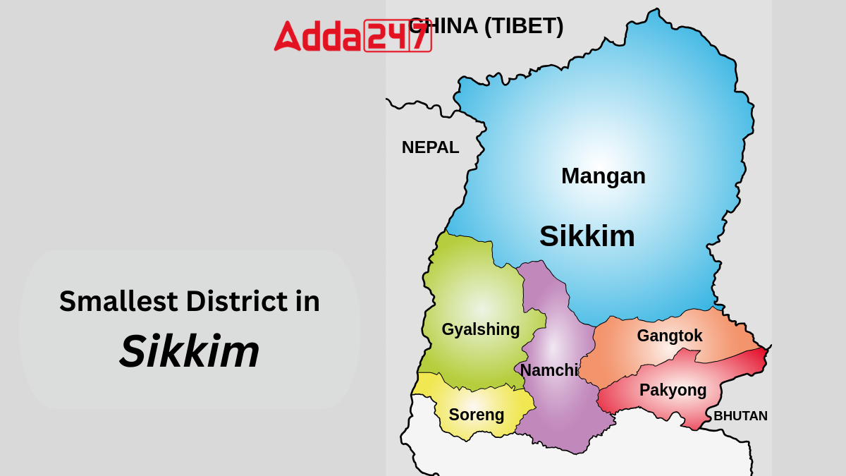
Soreng, the second newest district in Sikkim, spans across an area of 293.22 square kilometers, making it the smallest district in the state by official standards. Nestled in the picturesque landscapes of Sikkim, Soreng emerges as the newest and smallest district in this Himalayan state. With its rich cultural heritage, breathtaking vistas, and vibrant community, Soreng offers a captivating glimpse into the essence of Sikkim.
Smallest District of Sikkim by Land Area – Geographical Overview
Situated at coordinates 27.17°N 88.20°E, Soreng encompasses an area of 293.22 square kilometers, making it the smallest district in Sikkim. The district was recently carved out of West Sikkim, with its headquarters located in the town of Soreng. Despite its modest size, Soreng boasts of diverse terrain, ranging from precipitous slopes to serene river valleys.
Sikkim’s Smallest District – Connectivity and Accessibility
Soreng is well-connected to neighboring towns and cities via a network of metalled roads. It enjoys connectivity to the capital city of Gangtok as well as to prominent towns in West Bengal such as Darjeeling and Kalimpong through Jorethang. This accessibility enhances the district’s appeal to travelers seeking to explore its cultural and natural treasures.
Smallest District of Sikkim – Cultural Diversity and Language
Soreng is characterized by its multicultural populace, with a predominant Nepali population. The district is a melting pot of diverse ethnicities, including Bhutia, Lepcha, Limbu, Newari, Rai, Gurung, Mangar, Sherpa, Tamang, Sunwar, among others. This cultural mosaic is reflected in the vibrant traditions, languages, and customs that thrive within the community.
Climate and Geography of Sikkim’s Smallest District
Situated at an altitude of approximately 4314 feet, Soreng enjoys a temperate climate for the majority of the year. The region experiences distinct seasons, with mild summers, moderate winters, and occasional snowfall adding to its charm. The monsoon season, extending from May to November, brings abundant rainfall, nourishing the lush vegetation that blankets the landscape.
Economic Landscape of Smallest District in Sikkim
The economy of Soreng is predominantly agrarian, despite the challenging terrain that limits cultivable land. The district’s economy revolves around agriculture, with traditional crops being cultivated on the fertile plains and terraced fields. Additionally, Soreng is emerging as a favored destination for trekking enthusiasts, drawn to its high elevations and scenic trails.
Tourism in Soreng, the Smallest District in Sikkim
Soreng beckons travelers with its natural splendor and serene ambiance. From the verdant landscapes of the Rhododendron Sanctuary to the tranquil banks of the Ramma River, the district offers a myriad of attractions for nature enthusiasts and adventure seekers alike. Notable towns such as Nayabazar, Kaluk, Mangalbarey, and Rinchenpong serve as gateways to the region’s pristine wilderness.
Smallest District in Sikkim – Bordering Boundaries
Soreng shares its borders with Gyalshing and Namchi to the north, while the southern boundary is demarcated by the Ramma River. To the east, the district is bounded by the ChunbhattiKholsa and Rangit River, while to the west, it shares borders with the Rammam River and the Indo-Nepal border.
Sikkim State at a Glance
- Country: India
- Region: Northeast India
- Admission to union: 16 May 1975
- Capital and largest city: Gangtok
- Districts: 6
- State Legislature: Unicameral Sikkim Legislative Assembly (32 seats)
- National Parliament representation: 1 seat each in Rajya Sabha and Lok Sabha
- High Court: Sikkim High Court
- Total Area: 7,096 km2 (2,740 sq mi)
- Population (2011): 610,577; 32nd rank; density 86/km2 (220/sq mi)
- Official Languages: Nepali, Sikkimese, Lepcha, English
- Literacy rate (2011): 81.42% (13th)
- Sex ratio (2011): 890 females/1000 males (10th)


 Which Dance Form is known as the Ballad ...
 Which Musical Instrument is known as the...
 Which District is known as the Engineeri...


