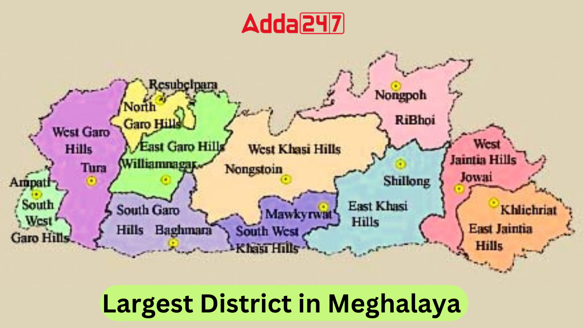
Meghalaya, the abode of clouds, is renowned for its pristine natural beauty, rich cultural heritage, and vibrant communities. Nestled in the northeastern part of India, this enchanting state boasts of breathtaking landscapes, cascading waterfalls, and dense forests. Among its many jewels lies the largest district in Meghalaya, the West Khasi Hills, a region teeming with diversity and charm.
How many districts are there in Meghalaya?
Meghalaya, a northeastern state of India, came into existence on January 21, 1972. It comprises 12 districts organized into three administrative divisions. Covering a land area of 22,429 square kilometers, Meghalaya was previously a component of Assam until its declaration as a distinct state in 1972.
Largest District in Meghalaya
West Khasi Hills, situated in the northeastern state of Meghalaya, India, stands out as the largest district within this enchanting region. Carved out of the Khasi Hills district on October 28, 1976, West Khasi Hills encompasses a rich tapestry of history, culture, and natural wonders that captivate the imagination of all who venture into its embrace.
Key Facts Related to Largest District in Meghalaya
Here are some key facts related to West Khasi Hills, the largest district in Meghalaya:
- Establishment: Carved out of Khasi Hills district, West Khasi Hills was divided into West and East Khasi Hills districts on October 28, 1976.
- Geography: Encompasses an area of 5,247 square kilometers with Nongstoin as its district headquarters.
- Divisions: The district is divided into four blocks: Mairang, Mawshynrut, Mawthadraishan, and Nongstoin.
- Demographics: Boasts a population of 383,461 as per the 2011 census, predominantly inhabited by the Khasi tribe with a notable presence of the Garo Tribe in Mawshynrut RD Block.
- Culture: Witnessing a transformation, with the adoption of Western lifestyles while retaining matrilineal laws and cultural traits.
- Places of Interest: Home to scenic attractions like Langshiang Falls, Mawthadraishan Peak, Nongkhnum River Island, Umyiap Paddy Field, Ranikor, Kyllang Rock, Rambrai, and Langpih village, subject to a territorial dispute.
Largest District of Meghalaya By Population
East Khasi Hills district in Meghalaya holds the distinction of being the most populous, with a population of 825,922. Established on October 28, 1976, it encompasses Shillong, the capital of Meghalaya, and is a hub of culture, commerce, and urban life. The district’s diverse terrain, rich cultural tapestry, and economic significance make it a vibrant center of activity, while also presenting challenges and opportunities for sustainable development and growth.
Districts of Meghalaya, Name List
Here is the comprehensive list of Meghalaya’s 12 districts, including their respective population and area coverage:
| Districts of Meghalaya | ||||
| S. No. | District | Area (in sq. km) | Population (2011) | Established |
| 1. | North Garo Hills | 1,113 | 118,325 | 2012 |
| 2. | East Garo Hills | 1,490 | 199,592 | 1976 |
| 3. | South Garo Hills | 1,850 | 142,334 | 1992 |
| 4. | West Garo Hills | 2,855 | 472,497 | 1976 |
| 5. | South West Garo Hills | 822 | 172,495 | 2012 |
| 6. | West Jaintia Hills | 1,693 | 270,352 | 2012 |
| 7. | East Jaintia Hills | 2,040 | 122,939 | 2012 |
| 8. | East Khasi Hills | 2,752 | 825,922 | 1976 |
| 9. | West Khasi Hills | 3,890 | 252,010 | 1976 |
| 10. | South West Khasi Hills | 1,341 | 110,152 | 2012 |
| 11. | Eastern West Khasi Hills | 1,356.77 | 131,451 | 2021 |
| 12. | Ri-Bhoi | 2,378 | 258,840 | 1992 |


 Which Animal is known as the Guardian of...
 Which Mountain Range Blocks Cold Winds i...
 Which was the First Book to Win the Book...


