
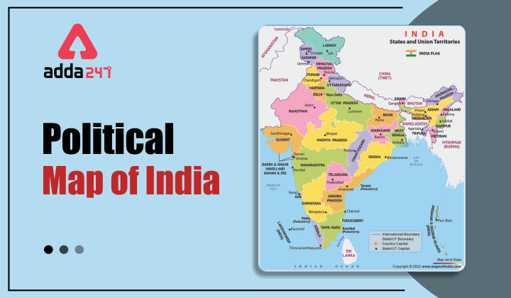
Political Map of India
In India Map, there are 28 states with 8 union territories. India has a coastline of 7,517 km, out of which 5,243 km belongs to peninsular India and 2094km belongs to the Andaman and Nicobar and Lakshadweep Island. There are six major zones of India, east, west, north, south, northeast, and Central India. The political map of India has been changed after the division of Jammu and Kashmir and Ladakh as two different union territories on 31st October 2019.
States and capitals of india 2022
The Jammu and Kashmir reorganization act of 2019
Parliament of India enacted the Jammu and Kashmir reorganization act because of the increasing dispute among the neighboring countries Pakistan and China. The bill for the reorganization act of Jammu and Kashmir was introduced by Amit Shah, Minister of Home Affairs. It was presented and passed by the Rajya Sabha on 5th August 2019. On 6th August 2019, the bill was passed by the Lok Sabha and the final approval of the president was granted on 9th August 2019. The act was passed to make Jammu and Kashmir, and Ladakh two administered union territories of India. The act consisted of 103 clauses, extends 106 Central laws of UT, 153 state laws repeals, and the abolition of the Jammu and Kashmir legislative council.
Provisions of the Jammu and Kashmir reorganization act
- The Jammu and Kashmir reorganization act divides India’s administered state into two administered union territories, Jammu and Kashmir, and Ladakh.
- Jammu and Kashmir will have a legislative assembly and Ladakh will be administered only by the lieutenant governor.
- Leh and Kargil are included as districts in Ladakh, while all the other districts are under the Jammu and Kashmir.
- There were six Lok Sabha seats in the previous state, now, Ladakh has one seat and all the other five seats are given to Jammu and Kashmir.
- Jammu and Kashmir and Ladakh will function under the same High court.
Restrictions and movements after the Jammu and Kashmir reorganization act
After the implementation of the Jammu and Kashmir reorganization act, the new union territories observed a complete lockdown and communication blackout. The restrictions in Kashmir were longer than in Jammu. The communication blackout was the longest in any democracy in history. From 5 to 6 August 2019, it was an emotional and anxious period for the people of Jammu and Kashmir. People were not happy with the decision taken by the government but no one was willing to speak on camera. People were expressing their anger which was a complete disaster. People criticized the government and called them “Iblees” which means Satan. This act also attracted the attention of foreign newspapers and news channels to which the Indian journalist said that it is not their responsibility to cover the protests in India, the change in Kashmir’s status has shifted their focus.
Geography of India in 2022
There are six major zones of India, east, west, north, south, northeast, and Central India.
- Eastern India includes four states and one union territory. Odisha, West Bengal, Jharkhand, and Bihar are the states that come under Eastern India, and Andaman and Nicobar Island is the only union territory under this part of the country. The total population of these states is 226,925,195 and the total area covered by this region is 418,323 sq km.
- Western India includes three states, Maharashtra, Goa, and Gujarat with only one union territory of Dadra & Nagar Haveli and Daman & Diu. The total area covered by this region is 508,052 sq km.
- In the northern part of the country, there are Himachal Pradesh, Punjab, Haryana, Uttarakhand, and Uttar Pradesh, with union territories of Delhi, Chandigarh, Ladakh, Jammu, and Kashmir.
- The southern part of the country includes states like Tamil Nadu, Kerala, Andhra Pradesh, Karnataka, and the Union Territories of Lakshadweep and Puducherry.
- In the Northeast part of India includes states like Arunachal Pradesh, Manipur, Assam, Tripura, Meghalaya, Mizoram, and Nagaland. These are called the seven sisters of India. Sikkim is also an important part of the Northeast region of India.
- The central Zone of India includes Madhya Pradesh and Chhattisgarh
FAQs related to the new political map of India
1. What is the new political map of India after bifurcation?
Ans. After the implementation of the Jammu and Kashmir reorganization act in 2019, Jammu and Kashmir are divided into two union territories as Jammu and Kashmir and Ladakh. The new political map of India has eight union territories and 28 states.
2. How many states are there in the new political map of India 2022?
Ans. There are 28 states in the new political map of India, after the bifurcation.
3. Which region of India has most of the union territories?
Ans. The north region of India has the most union territories. Delhi, Chandigarh, Ladakh, Jammu, and Kashmir are located in the northern region of the country.
Buy Prime Test Series for all Banking, SSC, Insurance & other exams


 Commonwealth Games 2026: Meet the Young ...
 Boomerang Nebula: The Coldest Place in t...
 Commonwealth Games Mascots: Complete His...

