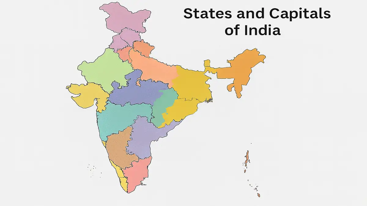
State and Capital
States and capitals of India: India is a country located in South Asia and is the seventh-largest country by land area. India is divided into 28 states and 8 union territories, each with its own capital city. The states and union territories are further divided into districts and subdivisions. The capital city of India is New Delhi, which is located in the National Capital Territory of Delhi. It is the administrative, political, and cultural center of the country.
The Jammu and Kashmir Reorganisation Act of 2019 designated October 31 as the designated day for the two Union Territories of J&K and Ladakh. It has never happened before for a state to be split into two Union Territories. With effect from January 26, 2020, India will have 8 union territories in addition to its 28 current states.
Countries Capital and Currencies
The Union Territories of Daman and Diu, Dadra and Nagar Haveli have become a single union territory since January 26 through a Bill passed by the Parliament in the winter session. With the merger of Daman and Diu, and Dadra and Nagar Haveli, the number of UT’s have come down to eight. The legislatures of three states Himachal Pradesh, Maharashtra and Uttarakhand meet in different capitals for their summer and winter sessions. Ladakh has both Leh and Kargil as its administrative capitals.
As students, you should know the complete list of Indian States and capitals List so that you can answer general Knowledge questions. Here, we are providing the latest list of Indian States and Capitals in 2023.
India is a federal union with 36 distinct entities made up of 28 states and 8 union territories. Within the states and union territories, districts and other administrative divisions are further divided. India’s states each have their own administrative, judicial, and legislative centres. According to some sources, all three duties are performed in the same capital. A Chief Minister is in charge of each state.
According to The States Reorganization Act 1956, the states of India were organized based on linguistic lines. There are 28 states and 8 Union Territories in India now. India consists of 400 cities altogether. India has eight metropolitan cities and they are Kolkata, Mumbai, New Delhi, Chennai, Hyderabad, Bangalore, Ahmedabad and Pune. The Prime Minister of India planned to develop 100 smart cities in India in the future. Indore bagged continuously 4 times the award of Smart city.
States and Capitals of India
Capital of India
Country | Capital |
---|---|
India | New Delhi |
Here is the complete list of 28 States and Capitals of India
S.NO | State | Capital | CM | Governor |
---|---|---|---|---|
1 | Andhra Pradesh | Amaravati | YS Jagan Mohan Reddy | Biswa Bhusan Harichandan |
2 | Arunachal Pradesh | Itanagar | Pema Khandu | B. D. Mishra |
3 | Assam | Dispur | Himanta Biswa Sarma | Jagdish Mukhi |
4 | Bihar | Patna | Nitish Kumar | Phagu Chauhan |
5 | Chhattisgarh | Raipur | Bhupesh Baghel | Sushri Anusuiya Uikey |
6 | Goa | Panaji | Pramod Sawant | P.S. Sreedharan Pillai |
7 | Gujarat | Gandhinagar | Bhupendra Patel | Acharya Dev Vrat |
8 | Haryana | Chandigarh | Manohar Lal | Bandaru Dattatraya |
9 | Himachal Pradesh | Shimla | Sukhvinder Singh Sukhu | Rajendra Vishwanath Arlekar |
10 | Jharkhand | Ranchi | Hemant Soren | Ramesh Bais |
11 | Karnataka | Bengaluru | Basavaraj Bommai | Thaawarchand Gehlot |
12 | Kerala | Thiruvananthapuram | Pinarayi Vijayan | Arif Mohammed Khan |
13 | Madhya Pradesh | Bhopal | Shivraj Singh Chouhan | Mangubhai Chhaganbhai Patel |
14 | Maharashtra | Mumbai | Eknath Shinde | Bhagat Singh Koshyari |
15 | Manipur | Imphal | N. Biren Singh | La. Ganesan |
16 | Meghalaya | Shillong | Conrad Kongkal Sangma | Brig. (Dr.) B. D. Mishra |
17 | Mizoram | Aizawl | Pu Zoramthanga | Kambhampati Haribabu |
18 | Nagaland | Kohima | Neiphiu Rio | Jagdish Mukhi |
19 | Odisha | Bhubaneswar | Naveen Patnaik | Ganeshi Lal |
20 | Punjab | Chandigarh | Bhagwant Singh Mann | Banwarilal Purohit |
21 | Rajasthan | Jaipur | Ashok Gehlot | Kalraj Mishra |
22 | Sikkim | Gangtok | PS Golay | Ganga Prasad |
23 | Tamil Nadu | Chennai | M. K. Stalin | R. N. Ravi |
24 | Telangana | Hyderabad | K Chandrasekhar Rao | Tamilisai Soundararajan |
25 | Tripura | Agartala | Dr. Manik Saha | Satyadeo Narain Arya |
26 | Uttar Pradesh | Lucknow | Yogi Aditya Nath | Anandiben Patel |
27 | Uttarakhand | Dehradun | Pushkar Singh Dhami | Lt. Gen. Gurmit Singh |
28 | West Bengal | Kolkata | Mamata Banerjee | Dr. C.V. Ananda Bose |
Complete list of 8 Union Territories
S.NO | Union Territories | Capital | CM | Lt. Governor |
---|---|---|---|---|
1 | Andaman and Nicobar Island | Port Blair | NA | D K Joshi |
2 | Chandigarh | Chandigarh | NA | Banwarilal Purohit |
3 | Dadra and Nagar Haveli and Daman and Diu | Daman | NA | Praful Patel |
4 | Delhi | Delhi | Arvind Kejriwal | Vinai Kumar Saxena |
5 | Ladakh | NA | NA | Radha Krishna Mathur |
6 | Lakshadweep | Kavaratti | NA | Praful Patel |
7 | Jammu and Kashmir | NA | NA | Manoj Sinha |
8 | Puducherry | Pondicherry | N. Rangaswamy | Dr. Tamilisai Soundararajan |
Types of Forest in India
Soil Map of India
Credit: mapsofindia
India Natural vegetation
Language Map of India
Folk Dance Map of India
Map of Pre-Partition of India
Credit: Mapof India
Indian state-wise Map
1. Map of Andra Pradesh
- Capital: Amaravati
- Area: 160,205 km²
- Governor: Syed Abdul Nazeer
- Chief minister: YS Jagan Mohan Reddy
2. Map of Arunachal Pradesh
3. Map of Assam
4. Map of Bihar
5. Map of Chhattisgarh
6. Map of Goa
7. Map of Gujarat
8. Map of Haryana
9. Map of Himachal Pradesh
10. Map of Jharkhand
11. Map of Karnataka
12. Map of Kerala
13. Map of Madhya Pradesh
14. Map of Maharashtra
15. Map of Manipur
16. Map of Meghalaya
17. Map of Mizoram
18. Map of Nagaland
19. Map of Odisha
20. Map of Punjab
21. Map of Rajasthan
22. Map of Sikkim
23. Map of Tamil Nadu
24. Map of Telangana
25. Map of Tripura
26. Map of Uttar Pradesh
27. Map of Uttarakhand
28. Map of West Bengal
Indian Union Territory wise Map
1. Map of Andaman and Nicobar Island
2. Map of Chandigarh
3. Map of Dadra and Nagar Haveli and Daman and Diu
4. Map of Delhi
5. Map of Jammu and Kashmir
6. Map of Lakshadweep
7. Map of Puducherry
8. Map of Ladakh
Largest State in India in terms of Area
S. No. | State Name | Area (km2) |
---|---|---|
1 | Rajasthan | 342,239 |
2 | Madhya Pradesh | 308,245 |
3 | Maharashtra | 307,713 |
4 | Uttar Pradesh | 240,928 |
5 | Gujarat | 196,024 |
6 | Karnataka | 191,791 |
7 | Andhra Pradesh | 162,968 |
8 | Odisha | 155,707 |
9 | Chhattisgarh | 135,191 |
10 | Tamil Nadu | 130,058 |
11 | Telangana | 112,077 |
12 | Bihar | 94,163 |
13 | West Bengal | 88,752 |
14 | Arunachal Pradesh | 83,743 |
15 | Jharkhand | 79,714 |
16 | Assam | 78,438 |
17 | Himachal Pradesh | 55,673 |
18 | Uttarakhand | 53,483 |
19 | Punjab | 50,362 |
20 | Haryana | 44,212 |
21 | Kerala | 38,863 |
22 | Meghalaya | 22,429 |
23 | Manipur | 22,327 |
24 | Mizoram | 21,081 |
25 | Nagaland | 16,579 |
26 | Tripura | 10,486 |
27 | Sikkim | 7,096 |
28 | Goa | 3,702 |
History of Indian Map
Credit: mapsofindia
Pre-Partition Map of India
You may also read this:
- Current Affairs Oneliner PDF 2023
- Monthly Current Affairs 2023 PDF
- Monthly Oneliner Questions PDF 2023
Buy Prime Test Series for all Banking, SSC, Insurance & other exams
Find More Miscellaneous News Here
States and Capitals of India: Question and Answers
Q.1 Presently, how many States and UTs are present in our country?
Answer: There are 28 states and 8 Union territories in the country which was in effect from 26th January 2020.
Q2. Who is the head of the Union Territories of India?
Answer: Lt. Governors & Administrators are considered to be the head of a Union Territories of India.
Q3. Name the state which has been bifurcated to make union territory.
Answer: Jammu and Kashmir state was split into two new Union Territories: Jammu and Kashmir and Ladakh.
Q4. What are the latest updates on the Union Territories of India?
Answer: Daman & Diu got merged with Dadar & Nagar Haveli in 2020.
Q5. Which is the smallest Union Territory of India?
Answer: Lakshwadeep is the smallest Union Territory of India.
It’s help me
Very HAPPY to see the information
Thanks for this
Thanks for this kind information 🙂. My exams are coming soon and this really helped me alot. Thank you 😌
Thanks for this it is helpful
So help full information
Thank you so much for value bule information
really helpful