
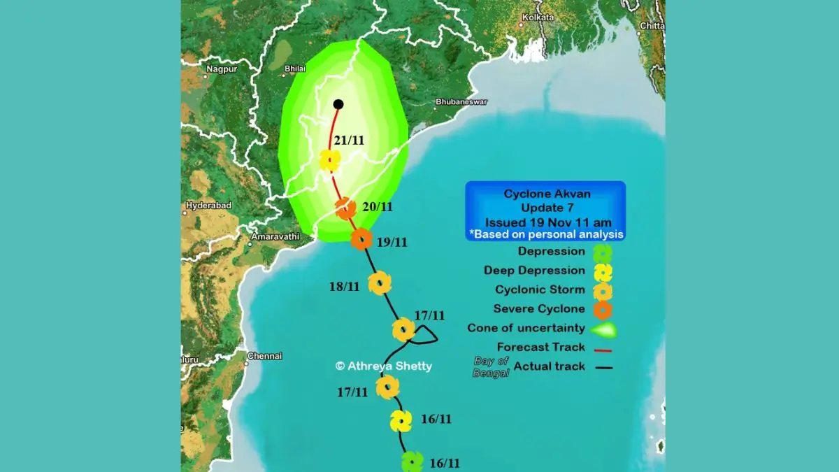
Cyclone Akvan has developed into a Severe Cyclonic Storm within the west-central Bay of Bengal. The India Meteorological Department (IMD) has forecast in its 19th November morning bulletin that the storm will Make Landfall on the coast of North Andhra Pradesh & Yanam and South Odisha between Narsapur and Puri (just to the East of Gopalpur) by midday on 20th November 2026. This storm is expected to cause strong winds of 90-100 kmph (with gusts of 110kmph) and heavy rainfall in the regions.
About Cyclone Akvan
Cyclone Akvan is a tropical cyclone that formed in the Bay of Bengal. On 18th November 2026, this storm developed into a Severe Cyclonic Storm.
Tropical Cyclones are large weather systems that can cause strong winds, heavy rainfall, rough seas, storm surges and coastal flooding.
Within its 9th November 2026 bulletin, the IMD reported that the storm was moving North at 12kmph.
Naming of Cyclone Akvan
The name Akvan has been provided by Iran within the regional list of tropical cyclone names managed by the WMO/UNESCAP Panel on Tropical Cyclones.
The current list of names, in operation since April 2020, contains 169 names. 13 names have been provided by each of the 13 contributing countries.
Bangladesh, India, Iran, Maldives, Myanmar, Oman, Pakistan, Qatar, Saudi Arabia, Sri Lanka, Thailand, United Arab Emirates and Yemen all contribute names.
Within the North Indian Ocean (Bay of Bengal and Arabian Sea), qualifying cyclones receive their names from the Regional Specialized Meteorological Centre (RSMC) in New Delhi, India.
Note: Although the list of names indicates that the name Akvan was provided by Iran, there is no official translation given.
When will Cyclone Akvan hit land?
The most up to date forecasting from the IMD indicates that Cyclone Akvan will be moving in a North-Northwest direction and strike land on the North Andhra Pradesh, Yanam (Pondicherry) and South Odisha coasts between Narsapur and Puri (close to the East of Gopalpur) by midday on 20th November 2026.
Compared to previous forecasts, the location of landfall has moved further North. Previously it was forecasted that the storm may Make Landfall between Machilipatnam and Puri.
- Landfall date: 20th November 2026
- Time: Approximately midday
- Region: Between Narsapur and Puri
- Likely location: Close to the East of Gopalpur.
- Regions affected: North Andhra Pradesh, Yanam & South Odisha.
- Further predictions may be made in future forecasts.
Intensity of Cyclone Akvan
It is forecasted that sustained winds of 90-100kmph will occur, with gusts of up to 110kmph.
Previous reports suggested that this storm may reach ‘Very Severe Cyclonic Storm’ status, however, the most recent forecasts do not support this, as wind speeds of 120-130kmph were not predicted.
States/Regions affected
This storm will affect weather in several states in the Eastern and Central regions of India.
- North Coastal AP, Yanam (Pondicherry): Heavy and Very Heavy rain, and isolated extremely heavy rain. Strong winds.
- South Odisha: Heavy and Very Heavy rain, and isolated extremely heavy rain. Strong winds.
- North Odisha: Heavy and Very Heavy rain
- Telangana: Heavy isolated rain in the Eastern part of the State on 20th November.
- Chhattisgarh: Heavy isolated rain on 20th & 21st November.
- West Bengal (Gangetic): Heavy and Very Heavy isolated rain on 20th November.
- Jharkhand: Heavy isolated rain on 20th & 21st November.
Isolated extremely heavy rains (21cm or more) are expected in parts of North Coastal AP and South Odisha on both 19th and 20th November.
Precautions
A Red Message has been issued for the coastal regions of North Andhra Pradesh, Yanam and South Odisha. Fishermen have been advised against entering these areas of sea.
Important precautions to take,
- Listen to advice from IMD and regional disaster management authorities.
- Evacuate from vulnerable coastal and low lying area into sheltered areas, if told to do so.
- Stay indoors during strong winds. Avoid staying in damaged or fragile buildings.
- Ensure you have essential medicine, water, food, torches and important documents.
- Avoid beaches, flooded roads, rivers and coastal areas.
- Follow advice from authorities regarding transport, evacuations and fishing restrictions.
Thatched and kutcha buildings, electrical systems, communication systems, standing crops, trees and transport systems may be damaged.








 India Revises Maritime Flag Rules After ...
 India’s Largest Underground LPG Storag...
 57th International Film Festival of Indi...