Rajasthan is India’s largest state, situated in the northwest region. It touches the international border, which makes several of its districts important for security, trade, and cultural exchange. These areas include wide desert landscapes, famous historical places, and significant military setups. The communities living here follow a distinct way of life influenced by the region’s traditions, environment, and interactions across the border.
An Overview of Rajasthan
Rajasthan is the largest state in India, covering 342,239 square kilometers. It is the northwest of the country and has the vast Thar Desert. Rajasthan shares its border with Pakistan and five Indian states: Punjab, Haryana, Uttar Pradesh, Madhya Pradesh and Gujarat. The Tropic of Cancer passes through its southern part. It is India’s seventh-largest state by population and has a rich cultural heritage.
Number of Districts of Rajasthan
Rajasthan is divided into 50 districts. These districts help in better administration and development. Each district has its own unique culture, history and geography. Some districts are in deserts, while others have fertile lands and historical sites.
Number of District of Rajasthan that share an International Border
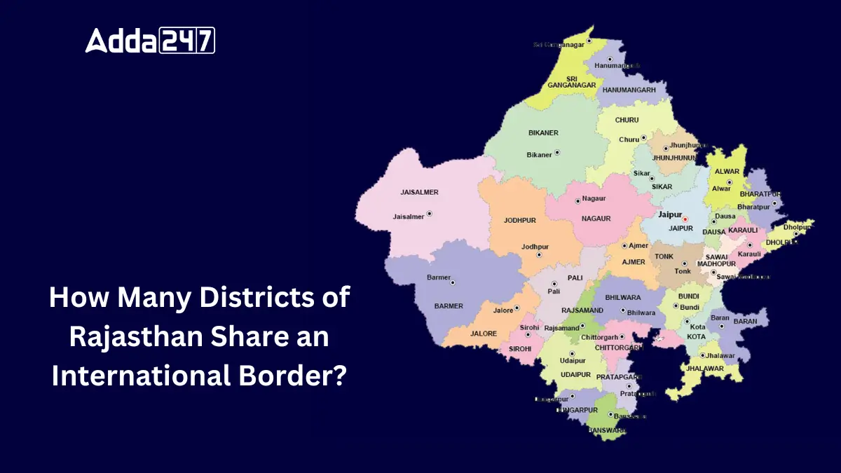
Rajasthan has 4 districts that share an international border. These districts are located along the western side of the state. They play an important role in security, trade and culture due to their proximity to the border.
Districts that Share an International Border
A total of four districts in Rajasthan share a border with Pakistan. These districts are:
- Jaisalmer
- Barmer
- Sri Ganganagar
- Bikaner
Significance of These Districts
These districts of Rajasthan are important for security, as they have military bases protecting India’s boundary. They also support trade between India and Pakistan. The culture of these areas is influenced by both countries, with shared traditions and languages. Additionally, these districts have desert landscapes, historical sites, and important defense infrastructure.

 Which Lake is known as the Jewel of Udai...
 Which is the Largest Banana Producing St...
 Which is the First Tiger Reserve of Utta...


