
The second cyclone of the post monsoon season is likely to form over southwest Bay of Bengal and hit the east coast in Tamil Nadu, Puducherry and Andhra Pradesh, the India Meteorological Department predicted.
Buy Prime Test Series for all Banking, SSC, Insurance & other exams
More About This Development:
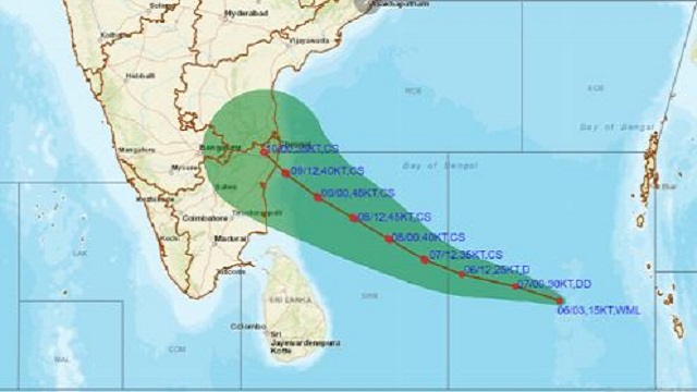
A low pressure area has formed over south Andaman Sea. It is likely to move west-northwestwards and become a depression over southeast Bay of Bengal by December 6 evening. It is likely to continue to move west-northwestwards, intensify further into Cyclonic storm Mandous, and reach southwest Bay of Bengal near north Tamil Nadu, Puducherry and adjoining south Andhra Pradesh by December 8 morning.
What Has Been Said:
We haven’t given a forecast for landfall yet. The models will provide a clearer picture tomorrow,” said RK Jenamani, senior scientist at the weather office.
“A cyclone is likely to form, but it may weaken before reaching the coast,” said Mahesh Palawat, vice president, climate change and meteorology at Skymet Weather Services, a private forecaster. “But coastal areas of Tamil Nadu and south coastal Andhra Pradesh will get heavy showers on December 7 and 8. It’s a fast-moving weather system.” Rains will start over north coastal Tamil Nadu, Puducherry and Karaikal from December 7 midnight and will likely increase on December 8 and 9, the weather bureau said.
How Intense It Will Be:
There is likely to be rainfall at most places over Andaman & Nicobar Islands. Squally weather with wind speed reaching 40-45 kmph gusting to 55 kmph is also likely. South Andhra Pradesh will see rains from December 7 midnight, which will increase on December 8 and 9. Wind speeds could reach 55-65 kmph gusting to 75 kmph on December 7, and gale wind speed reaching 70-80 kmph gusting to 90 kmph is likely on December 8.Squally winds reaching 40-50 kmph gusting to 60 kmph is likely along and off Tamil Nadu, Puducherry, south Andhra Pradesh and north Sri Lanka coasts from December 8, increasing to 60-70 kmph gusting to 80 kmph from December 8 evening to December 9 morning.
How The Western Disturbances Will Affect:
A feeble western disturbance is likely to affect Western Himalayan region from December 7. Under its influence, isolated light to moderate rainfall likely over Jammu and Kashmir, Ladakh and Himachal Pradesh on December 8. Minimum temperature is likely to fall by 2-3 degrees Celsius over Maharashtra in the next three days and rise by 2-3 degrees thereafter.
No significant change in minimum temperatures is likely over northern parts of the country in the next 4-5 days. Dense fog likely in isolated pockets over Himachal Pradesh in the morning and over Punjab and Haryana in the next 24 hours.
Read The Below Article To Know More About The Monsoon:
Indian Monsoon: This Year’s Performance And It’s Early Retreat


 Friendship Day 2026: Date, History, Sign...
 Gujarat's Pithora Painting Receives GI T...
 Air Marshal A K Bharti, Face of Operatio...

