
GAGAN (GPS Aided GEO Augmented Navigation), that is India’s indigenous Satellite-Based Augmentation System (SBAS) and it is jointly developed by the Indian Space Research Organisation (ISRO) and the Airports Authority of India (AAI), GAGAN improves the GPS accuracy, making aircraft navigation safer, more reliable and more precise. As it become fully operational in the year 2015, GAGAN has positioned India as among a select group of nations with advanced satellite-based navigation systems.
What is GAGAN?
GAGAN (GPS Aided GEO Augmented Navigation) is the India’s indigenous Satellite-Based Augmentation System which enhances the standard GPS signals by providing the real-time correction and integrity information.
Compare to conventional GPS, which may experience errors due to atmospheric disturbances, GAGAN continuously monitors the satellite signals and it corrects them and enables aircraft to navigate with much greater precision.
This system is specially valuable during aircraft approach and landing where navigation accuracy is crucial for passenger safety.
Why Did India Develop GAGAN?
As India is world’s one of the fastest-growing aviation markets, as air traffic increased the need for the highly accurate satellite navigation became essential.
Traditional GPS systems can suffer from signal inaccuracies caused by the atmospheric conditions and satellite clock errors. These minors inaccuracies may impact the aircraft navigation during critical flight phases.
To overcome these challenges, ISRO and AAI comes together and jointly developed GAGAN to,
- Improve GPS accuracy
- Enhance aviation safety
- Reduce navigation errors
- Enable satellite-based precision landing
- And build the indigenous navigation capabilities under the vision of Aatmanirbhar Bharat
How Does GAGAN Work?
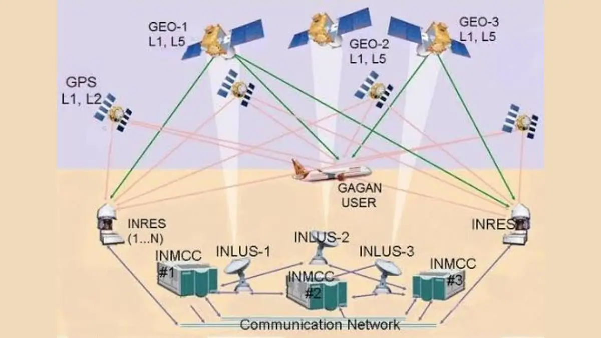
GAGAN functions through the nationwide network of ground stations, communication systems, and geostationary satellites.
This process involves several stages such as,
1. Monitoring of GPS Signals
Total 15 Indian Reference Stations (INRES) continuously tracks the GPS satellite signals all around the India and and it detects any positioning errors.
2. Processing of Corrections
Data from these stations is also transmitted to the two Indian Master Control Centres (INMCC), where the advanced algorithms calculate corrections and it verifies the signal integrity.
3. Uploading A Navigation Data
The corrected navigation information is sent through the three Indian Land Uplink Stations (INLUS) to the geostationary satellites.
4. Broadcasting to Aircraft
The satellites then broadcast the enhanced navigation signals to aircraft who are operating within India’s Flight Information Region and it allowing pilots to receive accurate positioning information in real time.
Key Components of GAGAN
India has deployed the robust infrastructure to support the GAGAN system.
| Component | Number | Function |
| Indian Reference Stations (INRES) | 15 | Monitor GPS signals |
| Indian Master Control Centres (INMCC) | 2 | Process corrections and integrity data |
| Indian Land Uplink Stations (INLUS) | 3 | Upload corrected data to satellites |
| Communication Networks | 4 | Connect all GAGAN stations |
| Geostationary Satellites | 3 | Broadcast corrected navigation signals |
This system currently operates using the GSAT-8, GSAT-10, and GSAT-15, which carry the dedicated GAGAN payloads.
India’s First Satellite-Based Landing Using GAGAN
A major milestone was achieved in the June 2026, when the Directorate General of Civil Aviation (DGCA) has successfully conducted the India’s first satellite-based landing system approach on a commercial aircraft by using GAGAN.
This achievement demonstrated the India’s capability to support precision approaches without depending entirely on to the traditional ground-based landing systems.
GAGAN vs NavIC: What is the Difference?
Although both the systems strengthens the India’s navigation capabilities, they serve different purposes.
| GAGAN | NavIC |
| Satellite-Based Augmentation System (SBAS) | Regional Navigation Satellite System |
| Enhances GPS accuracy | Provides independent navigation services |
| Mainly supports aviation | Supports navigation, positioning and timing |
| Provides correction and integrity information | Operates through India’s own satellite constellation |
| Covers Indian Flight Information Region | Covers India and up to 1,500 km beyond its borders |
Together, GAGAN and NavIC reduces the India’s dependence on foreign navigation systems and strengthening indigenous space technology.
International Recognition and Global Compatibility
GAGAN has been developed according to international civil aviation standards and it is fully interoperable with the leading global satellite augmentation systems, including the,
- WAAS (United States)
- EGNOS (Europe)
- MSAS (Japan)
GAGAN’s one of the most notable achievements is becoming the world’s first Satellite-Based Augmentation System certified for the equatorial region, where the satellite signal corrections are particularly very challenging.
Applications of GAGAN Beyond Aviation
Although it is designed primarily for the aircraft navigation, GAGAN’s precision positioning technology benefits the several sectors.
- Maritime Navigation
- Road Transport
- Railways
- Disaster Management
- Defence and Security
- Telecommunications
- Surveying and Mapping


 India Launches World’s First Nuclear P...
 BRICS Heads of Space Agencies Gather in ...
 India Gets First Approved Radioligand Th...

